Teaching Sea Level Rise
Hands-On Activities and Virtual Interactives
Sea level rise is one of the most visible and urgent impacts of climate change. This collection of classroom resources, videos, and hands-on science activities helps middle and high school students explore the causes and consequences of rising seas, including melting ice, warming oceans, extreme tides, and groundwater threats. Designed for secondary science educators, these adaptable lessons support NGSS-aligned learning and give students the tools to understand local impacts and engineer real-world solutions.
Swelling Seas
Why are sea levels rising? These resources help students explore two major causes—warming oceans and melting ice—through hands-on activities, climate models, and interactive visualizations. Together, they offer an entry point into the climate science behind a changing shoreline.

Swelling Seas
Science Snack
Warmer water takes up more space. In this simple Science Snack, students observe how rising temperatures cause ocean water to expand—one of the main drivers of sea level rise.

Melting Ice and Rising Seas
Science Snack
Melting ice is the major factor contributing to sea level rise, but how does the location of melting ice on Earth affect sea levels? Investigate with this model of seas and continents.
Extreme Tides: A Window of What’s to Come
High tides help us see what sea level rise will look like in our communities, now and in the future. These resources use King Tides and tidal cycles to help students make connections between daily ocean rhythms and long-term climate change, using data, models, and local observations.
Royal Tides: A Preview to Sea Level Rise
Video
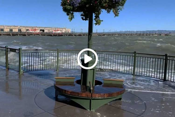
Royal Tides, also known as King Tides, show us what everyday high tides could look like as sea levels rise. This video, created in partnership with the Port of San Francisco, helps students explore how tidal extremes reveal future risks, and what actions we can take now to prepare.

Tide-o-matic
Science Snack
This hands-on activity models how and why tides occur, showing students the patterns behind high and low tides, and how rising seas may amplify their effects. It’s a useful foundation for understanding both tidal science and future climate impacts.
Groundwater and Sea Level Rise
Sea level rise doesn’t just threaten coastlines from above. It also pushes groundwater up from below, increasing flood risks, damaging infrastructure, and mobilizing buried contaminants. These resources help students and communities explore this often-overlooked hazard through scientific models, interactive maps, and classroom investigations focused on the Bay Area’s vulnerable urban landscapes.
Shallow Groundwater and Sea Level Rise
Interactive from Pathways Climate Institute, San Francisco Estuary Institute, UC Berkeley
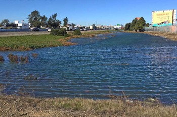
Explore the Shallow Groundwater and Sea-Level Rise ArcGIS StoryMap , which highlights how rising sea levels can elevate groundwater in Bay Area counties, threatening infrastructure, increasing flood risks, and mobilizing contaminants. This interactive resource combines research and visuals to emphasize the need for integrated, surface-and-subsurface climate planning.
Image credit and special thanks to Dr. Kristina Hill, UC Berkeley
Groundwater and Sea Level Rise Model
Science Snack (Under Development)
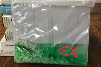
Help us test a new Science Snack! In this modeling activity, students investigate how sea level rise can infiltrate pore spaces underground, pushing fresh groundwater up and saltwater inland. Using simple materials, they can explore how this hidden hazard affects contaminants and groundwater levels near coastlines.
Note: This activity is still under development. Feel free to give us feedback!
Visualizations, Environmental Justice, Solutions, and Resilience
How can we prepare for the impacts of sea level rise in our communities? These resources invite students to explore real-world adaptation strategies through hands-on engineering, data exploration, and local planning tools. From modeling solutions to mapping flood risks, students engage in critical thinking and problem solving grounded in their own environments.

Engineering Solutions for Rising Seas: Shoreline Explorations
Classroom Resource (Under Development)
In this middle or high school activity, students learn about real-world adaptation strategies from the Port of San Francisco, then engineer their own solutions to sea level rise. This classroom-ready resource combines climate background with creative problem solving. Thanks to Daisy Yeung from Sequoia High School for sharing the student pages she developed for this activity.
Image: NOAA Tides and Currents
Note: This activity is still under development. Feel free to give us feedback!

Adapting to Rising Tides: Bay Shoreline Flood Explorer
Interactive from BCDC
This interactive tool developed by the Bay Conservation and Development Commission (BCDC) allows users to investigate potential flooding due to sea level rise and storm surges in Bay Area locations. As users change water levels to match future sea level scenarios, the Flood Explorer shows areas of inundation. Additionally, map layers include the potential consequences such as flooded infrastructure, transportation systems, and vulnerable communities, highlighting environmental justice issues of sea level rise.
Image: Adapting to Rising Tides Program, BCDC

Sea Level Rise Viewer
Interactive from NOAA
Developed by the National Oceanic and Atmospheric Administration (NOAA), this interactive mapping tool allows students and others to view potential flooding due to sea level rise for any coastal location in the US. As with these other interactive tools, users can change the sea level based on projections to observe future flooding.
Image: NOAA Sea Level Rise Viewer

Climate Central: Flood Risk to Hazardous Facilities in 2100
Interactive from Climate Central
This interactive mapping tool shows hazardous facilities in California that are at risk of future flooding due to sea level rise, tides, and storm surge. This tool also includes map layers including census data of the percentage of people living in poverty. Students can use this tool to build understanding of environmental justice issues facing these communities as sea levels rise.
Image: Climate Central
Resources
As Rising Seas Threaten Hazardous Sites, California’s Socially Vulnerable Communities Face Highest Risks: Study
Climate Central
Coastal Adaptation to Climate Change and Sea-Level Rise
by Gary Griggs and Borja G. Reguero
Water 2021, 13(16), 2151; https://doi.org/10.3390/w13162151
https://www.exploratorium.edu/education/teaching-climate-change